The Rocky Mountain Map Society is a non-profit organization dedicated to the study and appreciation of maps and other items of cartographic interest. The Society was formed in 1991 and is based in Denver, Colorado. Upcoming meetings, past events and other information can be found at the tabs above. We hope to see you soon!
Announcements:
-
RMMS Lecture Openings
-
We have some open slots in our 2026 lecture schedule. If you are interested in giving a talk, or know someone who would be a good fit, please contact Vincent.louis.szilagyi@gmail.com. Any and all map related topics are welcome, as are any level of speaker experience. Thank you!
-
-
The Influence of Four 1860 Territorial Censuses on the Development of the Colorado Map - Nancy Price
-
Tuesday, January 20, 2026 @ 5:30 PM
-
In 1860, Jefferson Territory overlapped Utah, Nebraska, New Mexico, and Kansas. Federal law included territories in the decennial census, providing more flexibility in counting residents than states received. Census data was originally collected to allocate representatives and manage taxation. Today, online census records provide detailed insights into families, communities, and migration. Census takers sometimes made mistakes but rarely missed entire settled areas.
-
Nancy Prince earned her master's degree at the University of Colorado - Denver, focusing her thesis on the dinosaur tracksite in the "Picketwire" canyons. Influenced by her parents, she developed an interest in genealogy and southern Colorado history. She has delivered presentations and published several articles about her ancestors, including those who settled along the Cherokee Trail during the territorial era.
-
This will be hosted in person at at History Colorado
-
1200 North Broadway, Denver, Colorado
-
Please register for a free ticket, please click this link.
-
Please enter the building at the main (front) entrance.
-
Parking information, click here.
-
-
This will also be hosted on Zoom. Zoom link here.
-
-
“Where the *%&^# is Polypotamia? Mapping proto-states in the early Republic” - Michael Buehler
-
Tuesday, February 24, 2026 @ 5:30 PM
-
This program addresses the question, “What do contemporary maps reveal about state creation in Trans-Appalachia in the years immediately after the Revolution?” What was Thomas Jefferson's role?
This program is illustrated using images of rare, important, and deeply interesting American maps of the era. -
Michael Buehler, owner of Boston Rare Maps, is a long-time collector of rare maps and historical prints. A specialist in the field, he has published articles on early American mapmaking, acted as guest curator of map exhibitions at the Harvard Map Collection and the Leventhal Map Center of the Boston Public Library, and is a regular public speaker.
-
This will be hosted in person at at History Colorado
-
1200 North Broadway, Denver, Colorado
-
Please register for a free ticket, please click this link.
-
Please enter the building at the main (front) entrance.
-
Parking information, click here.
-
-
This will also be hosted on Zoom.
-
Link coming soon.
-
-
-
New Feature in Colorado Magazine: “Lost and Found – Rediscovering Colorado’s Earliest Records” by RMMS member Larry Obermesik
-
We’re excited to share an engaging piece from Colorado magazine titled “Lost and Found: How my pandemic pastime led me to rediscover some of Colorado’s earliest records.” Over the course of the pandemic, RMMS member Larry Obermesik turned a quiet hobby into a remarkable journey through archives, unearthing forgotten maps, journals, and documents that shed new light on the early days of Colorado’s settlement.
-
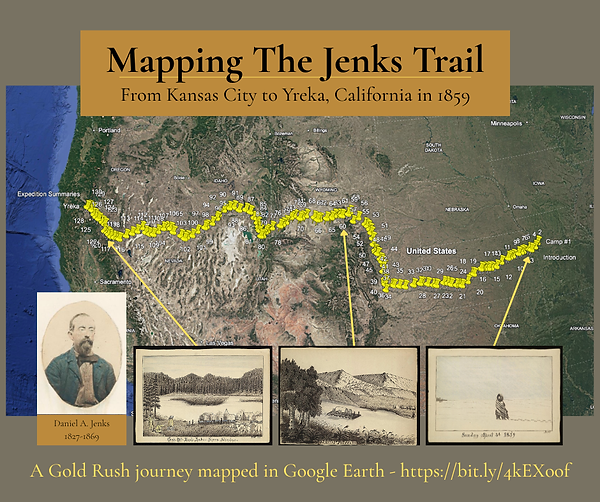
You may remember that Larry presented the story to RMMS last year of Daniel Jenks, the early Colorado gold miner, from the journal Larry discovered in the Library of Congress. Larry has gone on to do amazing research on the Jenks family and uncovered important documents of broader importance to share with other researchers.
-
-
Map Seminar: Mapping American Expansion
October 31-November 1-
Meeting Place: Winston-Salem, NC and Virtual
-
Two day seminar on October 31-November 1 focused on westward expansion during the 18th and 19th centuries, and featuring speakers such as Chet Van Duzer, JC McElveen, Wes Brown, Ashley Baynton-Williams, and Zack the Geography Geek.
-
The seminar will also include a map exhibition featuring Boston Rare Maps, Barry Lawrence Ruderman Antique Maps, Arader Galleries, and more.
-
-
A Mistake Map: Did putting El Paso in the wrong spot cost the US 10 million dollars? An article by Shaun Boyd
-
Karen Pinto, a scholar in the history of Islamic cartography, has a collection of maps on Pixeum.
-
Curtis Bird has YouTube interviews with various map makers (link)
-
Time Traveler's Map of Denver (link) - A site to compare historic maps of Denver with the current map.
-
Follow the Rocky Mountain Map Society on Facebook.
-
The Rocky Mountain Map Society has a YouTube Page now! Past talks are available to view whenever you like. Check it out!
-
The publications by RMMS Members page has recently been updated.
-
Our friend John Docktor has a wonderful list of all upcoming map events, not just in the USA, but across the pond as well. Please check it out!
-
RMMS is collaborating with outstanding map societies across the country for some Zoom meetings! Check out their websites!